| Beeldbank van Stichting Behoud Erfgoed NLR (SBEN) |
|
|
|

Klik op bovenstaande afbeelding voor een 100% weergave |
|
| Database nr. | : | 00305 |
|---|---|---|
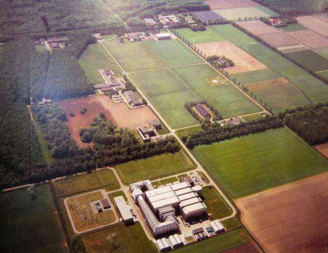
| Titel | : | NLR terrein Marknesse vanuit het noorden / NLR premises Marknesse from north |
| Instituut | : | NLR |
| Locatie | : | Marknesse |
| Datering | : | ca. 2000 |
| Bijzonderheden | : | Luchtfoto van het NLR-terrein in Marknesse. Prominent op de voorgrond de grote windtunnel (LLF) van de DNW. Daarboven de kleinere LST-windtunnel. Verder het gebouw van de Technische Diensten met geavanceerde werkplaatsen en het gebouw van de afdelingen Informatica en Avionica (centrumgebouw). Linksboven in het bos het gebouw van de Ruimtevaart-afdeling. Op het middenterrein onder de zgn. Tweede Landbouwschuur en boven de gebouwen van de afdeling Constructies en Materialen (incl. de Eerste landbouwschuur). Het witte vierkant rechts op het middenterrein is de buiten test site (OATS) voor Elektromagnetische Interferentie (EMI), tevens helikopterlandingsplaats. Rechts daarvan het O-gebouw, dat eerder het Elektronisch Laboratorium huisvestte. De smalle licht gekleurde strook rechts is de antenne test site. Midden boven aan de andere kant van Voorsterweg het kantoorgebouw van het voormalige Waterloopkundig Laboratorium (WL), in gebruik als bedrijfsverzamelgebouw voor het Geomatica Business Park. Aerial photo of NLR premises in Marknesse. Outstanding on the foreground the Large Low speed Facility (LLF) of the German Dutch Windtunnels (DNW). There above the smaller Low Speed Windtunnel (LST). Further the buildings of the Technical Services with the advanced workshop and of the Informatics and Avionics departments (central building). Top left in the forest the building of the Space department. On the central area the so-called second farmers barn and in the top the buildings of the Structures and Materials departments, including the first farmers' barn. The white square on the middle area is the open area test site (OATS) for Electro Magnetic Interference (EMI), also used as landing site for helicopters. On the right the building of the administrative services, formerly used as electronic laboratory. The small light-colored strip on the right is the antenna test site. In the middle of the top at the opposite side of the Voorsterweg the office building of the former WL/Delft Hydraulics, in use as building for the Geomatics Business Park. Zie ook foto's 00303, 00302, 00299, 00300, 00567, 00590, 00752, 00755 en 00767. |
| Fotograaf | : | |
| Collectienaam | : | |
| Rubriek | : | Gebouwen en terreinen |
| Subrubriek | : | Terreinen |
| Categorie | : | Foto: kleur |
| Achterkant afbeelding | : | |
| Afmetingen | : | |
| Rapportnummer | : | |
|
|
||
Record aangepast: 31 januari 2022